Poster: A snowHead
|
|
Here's a bad data point: last night I tried to get a reservation at Crystal for this coming Wednesday. None available. I will admit that I don't like that much. Trying to not overreact. Gonna try for a few parking reservations at Bachelor in mid January, I guess I'd better do it soon.
|
|

|
|
|
|
Obviously A snowHead isn't a real person
Obviously A snowHead isn't a real person
|
|
|
|
Well, the person's real but it's just a made up name, see?
Well, the person's real but it's just a made up name, see?
|
|
Another data point (and no, typically I don't issue a play-by-play of me trying to go skiing, but these are not typical times): Crystal just sent an email saying they'd released more slots, and sure enough, I got one for Wednesday. More questions than answers at this point, but at least we're strappin' them on...
|
|
|
|
|
|
You need to Login to know who's really who.
You need to Login to know who's really who.
|
|
|
|
Anyway, snowHeads is much more fun if you do.
Anyway, snowHeads is much more fun if you do.
|
|
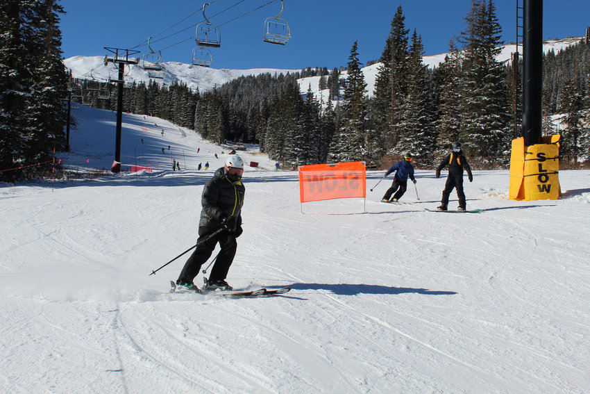
Crystal yesterday was a friggin zoo! As in: I left at 10! Long lines, lift stoppages, all lots full. "Capacity control"? Uh, no. Probably not the smartest day to go.
|
|
|
|
|
|
You'll need to Register first of course.
You'll need to Register first of course.
|
|
|
|
|
|
|
Nice! Surprised there was that much left on the cone with all those cars in the lot.
|
|
|
|
|
|
|
|
| Scooter in Seattle wrote: |
| Nice! Surprised there was that much left on the cone with all those cars in the lot. |
Lots of people headed up higher. About 100 cars parked along Sunrise area. Bachelor should open the parking lot at Sunrise to get the cars off Century Drive. Just based on the amount of traffic that was on Century as I headed it out, it will be interesting to see what crowds will be like once the lifts start spinning.
My younger brother was up at Crystal on Wed. too. Sounded like a real mess. Glad I decided to ski on Monday instead.
|
|
|
|
|
|
You'll get to see more forums and be part of the best ski club on the net.
You'll get to see more forums and be part of the best ski club on the net.
|
|
|
|
|
|
Was pretty crazy busy at Cypress - did a few runs and left.
At least I guess that means people heeded the advice/request not to go to Whistler, though I wonder if Whistler could handle to volume better, so telling Vancouver to go to Cypress/Seymour/Grouse may actually make things worse?
|
|
|
|
|
|
snowHeads are a friendly bunch.
snowHeads are a friendly bunch.
|
|
|
|
And love to help out and answer questions and of course, read each other's snow reports.
And love to help out and answer questions and of course, read each other's snow reports.
|
High pressure will start to breakdown in the PNW this week around Wednesday. BC in to the interior will do very nicely from a series of storms coming through. Jet stream will finally start to sag to the South by the weekend allowing for the Rockies to get in on the action.
Meanwhile it’s wall to wall groomers and sunshine in Jackson Hole

|
|
|
|
|
|
|
|
More single digits and snowmaking at JHMR.
Fast groomers and more employees on mtn than skiers.

|
|
|
|
|
|
You know it makes sense.
|
Nasty warm and rainy in Seattle today - not doing Cascades snow pack much good 
|
|
|
|
|
|
Otherwise you'll just go on seeing the one name:
Otherwise you'll just go on seeing the one name:
|
| gortonator wrote: |
| Nasty warm and rainy in Seattle today - not doing Cascades snow pack much good |
Might be late Saturday/Sunday for the snow to return to the Cascades but it is coming!
|
|
|
|
|
|
Poster: A snowHead
|
yep - hopefully bigly!! I may work this weekend so i can sneak a day trip to Crystal midweek maybe 
|
|
|
|
|
|
Obviously A snowHead isn't a real person
Obviously A snowHead isn't a real person
|
Nothing but sunshine and corduroy at JHMR. Weather is supposed to change late Thursday for Colorado Rockies and Montana into the Tetons. British Columbia has been getting all the cold smoke powder so far.
Jet stream starts to move South and with it will bring moisture and cold air and start to march across the PNW into the North Rockies by the weekend.

|
|
|
|
|
|
Well, the person's real but it's just a made up name, see?
Well, the person's real but it's just a made up name, see?
|
Surprised no Canucks posting on all the snow you’re getting up North.
Another day of sun and man made before the storm arrives here in Jackson Hole.

|
|
|
|
|
|
You need to Login to know who's really who.
You need to Login to know who's really who.
|
Light snow today with flurries off and on. More snow coming this evening.

free image hosting
|
|
|
|
|
|
Anyway, snowHeads is much more fun if you do.
Anyway, snowHeads is much more fun if you do.
|
Some nice turns at JHMR yesterday. Soft and light. About 5”-6” of cold smoke powder. More accumulation coming to most Western ski area this week.

|
|
|
|
|
|
You'll need to Register first of course.
You'll need to Register first of course.
|
Lots of snow inbound for the Cascades from Mt Baker down to Mt Bachelor. Storm came in a bit on the warm side and is cooling as the storm moves through. Should be some good base cover with possibly 2 feet of snow at higher elevations over the next 72 hours.
By the looks of things Utah and Colorado are getting some decent snow as well. Should be a white Christmas for most ski areas. Of course, keep your distance and wear your masks if you decide to hit the slopes this holiday.
|
|
|
|
|
|
|
|
Temps were on the higher side, so were the winds. About 6" of cream cheese to carve up at Bachelor this morning.
Much too crowded for my liking.

|
|
|
|
|
|
|
|
Mellow day in the Cascades

|
|
|
|
|
|
You'll get to see more forums and be part of the best ski club on the net.
You'll get to see more forums and be part of the best ski club on the net.
|
|
Looking good.
|
|
|
|
|
|
|
|
Snow forecast for Christmas day in the PNW. Right now it doesn't appear to be much of a storm. Cool temps, and current models showing a few inches, maybe 6 inches higher up over a 24 hour period. Need another day to watch things develop. But temps will remain cold.
More storm energy will be focused down in the Sierras and Tahoe on Christmas day late evening into Boxing Day. Should see a few inches to maybe a foot by Saturday late morning. Then a 2nd storm is currently taking shape in the GFS with a Sunday evening/Early Monday morning time frame. Too soon to know exactly where it will focus it's energy but could bring a nice refresh. Possibly sneak up the West Coast into Southern Oregon.

Out into FI type range seems to show some potential for a brief high pressure to build up for a few days, then possibly return to storminess for the New Year.
|
|
|
|
|
|
snowHeads are a friendly bunch.
snowHeads are a friendly bunch.
|
|
Crystal got 8" last night after it cooled off, a much needed boost to coverage. But by 10:30 it was a zoo, I'm done until after 1/1.
|
|
|
|
|
|
And love to help out and answer questions and of course, read each other's snow reports.
And love to help out and answer questions and of course, read each other's snow reports.
|
| Scooter in Seattle wrote: |
| Crystal got 8" last night after it cooled off, a much needed boost to coverage. But by 10:30 it was a zoo, I'm done until after 1/1. |
My younger brother was up there skiing yesterday. Said there was a lot of long lift lines, and I think it might have been REX that was stop and go that also didn't help with the lift lines either. So much for the Alterra reservation system. I'm guessing the pressure to let people use their season passes trumps COVID social distancing.
|
|
|
|
|
|
|
|
Many lift stoppages yesterday as there was a ton of rime due to the crazy storm the night before. Took 20 minutes to get up Chinook, a 6 minute ride. I don't normally give Crystal a break as they have earned our skepticism, but that was a tough weather situation to recover from. Believe it or not, the day before Seattle set records for both daytime high temp and rainfall, and at 5pm it began to snow. So not a big surprise that there was a mess waiting for us.
Crystal, and I'm assuming everywhere, is running out of parking because WAY more people are driving solo, including me. So the lots and lift lines are crazy. The slopes themselves not so much, fortunately.
I also heard that many people are cancelling at around 6-7am day of their reservation. To which I said: duh! I think running a ski area is hard and it has to be quite a bit harder now. Glad someone wants to do it!
|
|
|
|
|
|
You know it makes sense.
|
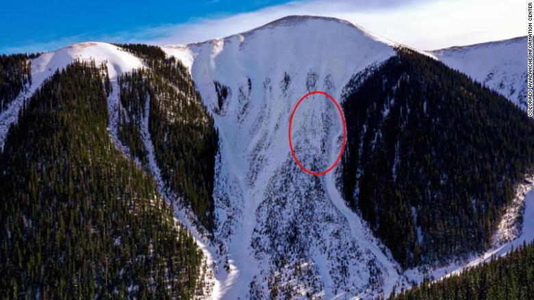
Colorado snowpack very unstable right now.
Big slides and three dead during the weekend, near Telluride.
|
|
|
|
|
|
Otherwise you'll just go on seeing the one name:
Otherwise you'll just go on seeing the one name:
|
Storm track favoring the Tahoe ski areas for Friday night/Saturday for a foot or so on higher elevations.
North Cascades should see snow also on Friday and Saturday. Maybe 6"-8" of snow. Depends on temps and wind directions, which will be more of a SW flow from this storm. So temps will be a bit warm to kick things off and drop as the storm passes through.
Central and South Cascades might see 5"-6" or so from Friday evening into Saturday. Again temperatures will play a roll in snow amounts. Might be a bit heavier snow. Nice refresh that is needed after a bit of a dry spell.
Tetons are on track to see some snow on Sunday from the storm moving inland from the Cascades. Northern Idaho and Big Sky, MT should also see snow on Sunday.
CO Rockies should also see some snow around the start of the week.
|
|
|
|
|
|
Poster: A snowHead
|
Interior BC got hit by storm on Tuesday, really good conditions.
The backcountry hazard is a subject on the main news because of persistent weak layers from Nov warm spell Basically they are recommending no one goes out.
|
|
|
|
|
|
Obviously A snowHead isn't a real person
Obviously A snowHead isn't a real person
|
|
|
|
Well, the person's real but it's just a made up name, see?
Well, the person's real but it's just a made up name, see?
|
@Toadman, how is coverage now? I gauge it in two places: the hourglass on Osprey near the top, where the run comes under the chair; and the first three turns after you leave the cat tract going from PM to Thunderbird and commit to Canyon or Coffee. Guessing the former is not ready and the latter could be.
The stuff on Red (or Rainbow) looks sweet. If those aren't turns by Patrol, it looks like they hit the tower! I finally get down there on the 25th. The reservations have sure filled up. Also guessing the slopes are not super crowded as there are so many more single occupant vehicles coming these days the lots fill but the slopes don't (perhaps a minor silver lining).
|
|
|
|
|
|
You need to Login to know who's really who.
You need to Login to know who's really who.
|
| Scooter in Seattle wrote: |
@Toadman, how is coverage now? I gauge it in two places: the hourglass on Osprey near the top, where the run comes under the chair; and the first three turns after you leave the cat tract going from PM to Thunderbird and commit to Canyon or Coffee. Guessing the former is not ready and the latter could be.
The stuff on Red (or Rainbow) looks sweet. If those aren't turns by Patrol, it looks like they hit the tower! I finally get down there on the 25th. The reservations have sure filled up. Also guessing the slopes are not super crowded as there are so many more single occupant vehicles coming these days the lots fill but the slopes don't (perhaps a minor silver lining). |
@Scooter Coverage is very good. There have been some high winds that have scoured the ridges off of Pine Martin, but otherwise the trees around Thunderbird, Tippytoe and Coffee are solid. Same for NWX and Outback. Although another foot on skiers right of Boomerang is in order.
As far as crowds go, it all depends on what's open. First day skiing was on a Thursday and Pine Martin and Red Chair were on a wind hold for about 45 minutes, and the lines were bad. I actually have not been over by Sunrise Village, so I have no idea what things are like over there. I tend to stay over on the NW side of things unless Summit is spinning, which I haven't seen yet this season. And yes those tracks were from patrol. Watched them enjoying their chair lift pole support inspections.
Underneath Northwest Express.

More incoming for Wed/Thursday with mi 20F temps. Not sure about totals. Maybe another 5"-8".
|
|
|
|
|
|
Anyway, snowHeads is much more fun if you do.
Anyway, snowHeads is much more fun if you do.
|
Some decent snow totals for SW CO this morning. 9" at Telluride. Silverton and Wolf Creek 19". Aspen/Snowmass 11". Steamboat summit telemetry indicating about a foot.
PNW and BC (Whistler-Blackcomb) on track for storm to arrive later this afternoon. Potential for over 2 feet at Mt Baker and Stevens Pass. A lot will depend on temps, as is always the case with a mtn snow storm!
GFS and ECM still showing more storminess right on the heels of the Wed/Thursday storm with another one arriving Friday afternoon into Saturday. Again the temps will yo-yo with the arrival and departure of the storms.
There also appears to be another storm set to arrive later Sunday into Monday that will bring more snow to the Cascades. This one is currently tracking a bit farther South with the Jet stream possibly moving farther South than it's current position up just North of the US/Canada border.
All indications are for a snowy end to 2020 and a snowy start to 2021.
Farther out into the latter part of the first week of January has more potential for more storms to come ashore off the Pacific.
|
|
|
|
|
|
You'll need to Register first of course.
You'll need to Register first of course.
|
Snowing heavily in the Cascades. Did a half day this morning at Bachelor. A meager inch on the corduroy (velvet  ) this morning, with snow coming down. When I left just before 1pm, the snow stake was reading 5". So about an inch an hour coming down. But high winds closed upper lifts around noon. Sounds like the same situation for Crystal Mtn., which is reporting 7", Stevens Pass with 6", and Whistler with a metric 22 cm's! ) this morning, with snow coming down. When I left just before 1pm, the snow stake was reading 5". So about an inch an hour coming down. But high winds closed upper lifts around noon. Sounds like the same situation for Crystal Mtn., which is reporting 7", Stevens Pass with 6", and Whistler with a metric 22 cm's!
By tomorrow, most Cascade Mtn ski areas should have 10" plus of snow when the lifts start spinning on Thursday. Not a bad way to start New Year's Eve with a powder day. Then a brief respite on Thursday afternoon with a bit of clearing our high clouds into Friday morning. Then some time Friday afternoon the next storm comes in. That should have a refresh of 5"-10" for most ski resorts for Saturday. Then another storm follows on the heels of the Friday/Saturday storm with a 3rd storm for Sunday. And then....another storm comes in on Monday morning. And, yes, there's more! A storm is looking likely for this up coming Wed/Thursday of next week. This storm is currently forecast to track somewhat further South than the previous powder train of storms that are favoring from Whistler down to Crystal Mtn, WA.
Going out even further into FI, the GFS and ECM are indicating potential for another wave of storms for the West Coast around January 9th-10th time frame.
|
|
|
|
|
|
|
|
|
Report of a slide with one buried at MHM today. Just out the 1/2 Moon gate. Recovery by several quick acting skiers nearby.
|
|
|
|
|
|
|
|
| Toadman wrote: |
| Report of a slide with one buried at MHM today. Just out the 1/2 Moon gate. Recovery by several quick acting skiers nearby. |
Where's MHM? 
|
|
|
|
|
|
You'll get to see more forums and be part of the best ski club on the net.
You'll get to see more forums and be part of the best ski club on the net.
|
|
Over here....Mt. Hood Meadows....1 hour east of Portland, OR. A good small area, something for everyone.
|
|
|
|
|
|
|
|
Not too bad this morning with some 4" of fresh on top of 6" fresh.

|
|
|
|
|
|
|
|