Poster: A snowHead
|
@LittleBullet, you'll love the skiing at aspen snowmass , all four hills have their own identity and the town is pretty cool too , snow is cold and light so don't need much to make the skiing great , watch out for the altitude to hit after a couple of days 
|
|

|
|
|
|
Obviously A snowHead isn't a real person
Obviously A snowHead isn't a real person
|
| LittleBullet wrote: |
| @Toadman, thanks for this. Really appreciated. Helped us a lot with planning. We're going to stick to the plan and head to Aspen-Snowmass Saturday evening for Sunday through to Tuesday riding. Keep these storms coming! |
Hope it works out for you with the weather. Enjoy the trip. If you get a chance, give Meat & Cheese and Farm Shop a try in Aspen. Great vibe and atmosphere along with good food.
|
|
|
|
|
|
Well, the person's real but it's just a made up name, see?
Well, the person's real but it's just a made up name, see?
|
|
|
|
You need to Login to know who's really who.
You need to Login to know who's really who.
|
|
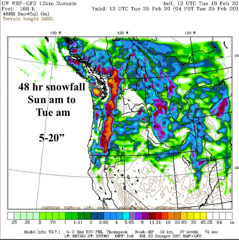
High pressure will and has started to build up over the PNW and California area. That will progress over the Rockies later. May still be some small bits of storm energy that works its way out of Colorado later today into Tuesday morning. It does appear that there could be some storm activity coming in from the South that will push over SW Colorado and New Mexico the end of the week. There's also some suggestions of a low pressure trough pushing the HP out of the PNW this weekend. Stay tuned.
|
|
|
|
|
|
Anyway, snowHeads is much more fun if you do.
Anyway, snowHeads is much more fun if you do.
|
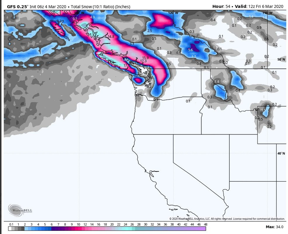
GFS and Euro starting to show some signals for return to snowy around the weekend for the PNW and the Rockies possible on Sunday. There's also some moisture tracking South off the Pacific off the Central CA coast. That currently is looking to come through Southern Utah and New Mexico around Sunday/Monday. It is still too soon to know if it will stay South as it moves East, or if it might drift up over SW Colorado and the San Juans. The HP off the West Coast may cause the storms to split and lose energy. Will need to keep an eye on things the next couple of days.
There's still some lingering activity in Colorado. Both Steamboat and Winter Park did quite well the past 3 days. About 20" to 26" for those areas. The good news is that there is cold air in place, and that will keep the snow well preserved. It was a chilly 9F in Aspen this morning. Heck I woke to 13F at my house in Oregon (4,000')
5 day outlook is mostly dry other than Colorado.

|
|
|
|
|
|
You'll need to Register first of course.
You'll need to Register first of course.
|
|
Lot of deaths at Mount Hood this season.
|
|
|
|
|
|
|
|
GFS looks promising for a storm for Sunday into Monday for BC and the PNW.
|
|
|
|
|
|
|
|
| Whitegold wrote: |
| Lot of deaths at Mount Hood this season. |
https://www.kgw.com/article/news/local/snowboarder-found-dead-in-heather-canyon-at-mt-hood-meadows/283-f74e3f04-0bf5-4ec5-b37d-a007c480cb06
Boarder was somewhere he shouldn't have been. Heather Canyon is no joke when it comes to the terrain you can access there. If you are a newbie to the area, you can get into a lot of trouble very easily. Especially if you duck a rope. They are there for a reason.
Mt. Hood Meadows General Manager Greg Pack says a visitor told ski patrol on Friday that they saw a person go through a roped-off, closed Double Black Diamond terrain area in Heather Canyon. Ski patrollers were sent out but didn't find anyone or see evidence.
Then "additional information" was provided to Meadows over the weekend, allowing them to narrow down their search and recover Bauters' body, .
"He was in an area where we have some open water and each of those open water areas there's waterfalls back in there. We rope off the entire thing leading up to it and the edges so you don't go in there. Unfortunately he went underneath the rope line and accessed into that area," Pack told KGW. "I can't say whether it's intentional or not. You know, never ever cut a rope line, they are there for a reason. They are there to protect you from going into areas you shouldn't be in."
|
|
|
|
|
|
You'll get to see more forums and be part of the best ski club on the net.
You'll get to see more forums and be part of the best ski club on the net.
|
|
|
|
|
|
| Whitegold wrote: |
| Lot of deaths at Mount Hood this season. |
Tragic. Heather canyon is one of my fave places on earth, but def want to follow patrol advice. The avalanche that came down last year was beyond immense!
|
|
|
|
|
|
snowHeads are a friendly bunch.
snowHeads are a friendly bunch.
|
My former stomping grounds. Did you manage to hit up the Double Musky for dinner?
|
|
|
|
|
|
And love to help out and answer questions and of course, read each other's snow reports.
And love to help out and answer questions and of course, read each other's snow reports.
|
Good watch.
Got a link to the tune?
|
|
|
|
|
|
|
|
Latest GFS runs showing a bit less oomph to the low pressure trough coming in on Saturday. Still will produce snow on Sunday for BC Coast Range and Northern Cascades but as the storm moves from the NW to the Southern Cascades and inland the precip will be less than previous models. Still a refresh of the slopes with a few inches is a good thing.
Forecast for Southern Utah and SW Colorado still looks on track. Wolf Creek usually does well in these SW flows. Telluride should see snow on Sunday into Monday, with Monday being the better day.
Tetons might get a dusting as well on Sunday/Monday.
3 day outlook showing a bit less moisture for SW Colorado and interior and Oregon looks to be on the short side from previous runs.

|
|
|
|
|
|
You know it makes sense.
|
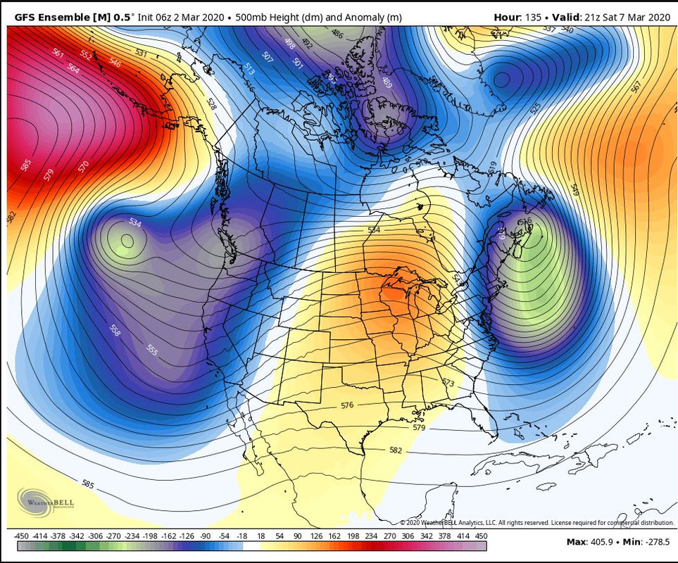
High pressure across most of the West Coast. That will stay in place until the weekend. There's a low pressure system way off the along the Aleutian Islands that will work it's way over and then down BC. Currently tracking to move down through Washington Cascades and into Oregon. It's not a strong, or very big system. Too soon to say for certain how the storm will track and how far South it will push.
Out in FI, there appears to by another system percolating that looks to come in around Tuesday/Wednesday next week. That one currently looks to come in farther East and dropping down from Interior BC, and through Montana, Wyoming and into Northern Colorado. Again too far out to have any certainty in storm track and moisture content. Stay tuned.
|
|
|
|
|
|
Otherwise you'll just go on seeing the one name:
Otherwise you'll just go on seeing the one name:
|
|
|
|
Poster: A snowHead
|
|
Ouch.
|
|
|
|
|
|
Obviously A snowHead isn't a real person
Obviously A snowHead isn't a real person
|
@Toadman, out to BC next Tuesday , looking like small steady top ups for next week or so , is that how you see it for coastal range ??
got a chance of skiing the tantalus mountains for first time and hoping the snow will stop in time as no viz no go
|
|
|
|
|
|
Well, the person's real but it's just a made up name, see?
Well, the person's real but it's just a made up name, see?
|
| Dabber wrote: |
@Toadman, out to BC next Tuesday , looking like small steady top ups for next week or so , is that how you see it for coastal range ??
got a chance of skiing the tantalus mountains for first time and hoping the snow will stop in time as no viz no go |
There's some weather coming in for Friday/Saturday. There's currently a SW flow, so that means warm air in the area until Friday. As the storm moves through the temps will drop, maybe down to base of WB. Because of the wind direction, the storm will probably split as it goes inland. Current forecast is for about 10cm-20cm, although higher up in the Alpine, I wouldn't be surprised if they see somewhere in the 30cm+ range.
There is a stronger storm on the GFS and Canadian runs looking to come in around Sunday night or early Monday. That storm might produce some decent accumulations. Will have to wait a few more days to see how this storm develops. A bit far out ow to have certainty in snow amounts.
|
|
|
|
|
|
You need to Login to know who's really who.
You need to Login to know who's really who.
|
@Toadman, cheers , seems this winter has turned out alright after the very shaky start up in coastal BC , can't wait to get out and some cold low snow would be excellent 
|
|
|
|
|
|
Anyway, snowHeads is much more fun if you do.
Anyway, snowHeads is much more fun if you do.
|
Latest GFS still shows the same system and tracking. As stated earlier, the storm will come in warm, and progressively cool down as the storm passes through the Coast Range and the Northern/Central Cascades. So, right side up pow! Oregon will get the left overs later Saturday. Colorado and the Tetons will also get into the action later Saturday/Sunday.

|
|
|
|
|
|
You'll need to Register first of course.
You'll need to Register first of course.
|
Currently snowing mid mountain at Whistler Blackcomb - They should see about 16cm or so during the day. After the lifts close, another 16cm or so should fall, leaving for nice skiing on Saturday. Monday evening into Tuesday morning looks to be another refresh with possibly 10cm-15cm over a 24 hour time frame. Colder temps should equal some nice soft turns.
Cascades will see a bit less snow, except the snow magnet, aka, Mt. Baker looking to see about 30cm Friday into Saturday. As is always possible, Central Cascades can do well from these NW flows. Especially Stevens Pass with cold East air flowing through the pass. Maybe 30cm of fresh on the upper mtn.? You don't know until you go!
Mt. Hood will get some left overs on Saturday into Sunday, and if I'm lucky, Bachelor will get some crumbs Saturday afternoon into Sunday for a refresh of the slopes.
That storm will trek East over the Tetons and drop down into Colorado on Sunday into Monday. Should see Central Mtns and Steamboat getting about 6" of snow. Wasatch looks to be on the edges of the storm, but Pow Mow, and Snow Basin could also squeeze out 6" or so as well.
|
|
|
|
|
|
|
|
|
|
|
|
|
|
|
|
You'll get to see more forums and be part of the best ski club on the net.
You'll get to see more forums and be part of the best ski club on the net.
|
|
|
|
|
|
|
|
|
snowHeads are a friendly bunch.
snowHeads are a friendly bunch.
|
For those up in Northern BC and interior should see snow falling at Kicking Horse and Panorama, there will be some snow flurries at WB today with more snow on the way for later in the week around Thursday. WB looks to get about 20" or so out of the Thursday storm.
A storm that tracked through CO on Sunday delivered about 6"-10" at Crested Butte and Aspen. High Pressure builds for the rest of the week in the Colorado Rockies.
|
|
|
|
|
|
And love to help out and answer questions and of course, read each other's snow reports.
And love to help out and answer questions and of course, read each other's snow reports.
|
| Toadman wrote: |
| For those up in Northern BC and interior should see snow falling at Kicking Horse and Panorama, there will be some snow flurries at WB today with more snow on the way for later in the week around Thursday. WB looks to get about 20" or so out of the Thursday storm. |
looking good for drive up to whistler Wednesday then some good old storm skiing on Thursday , hoping for thing to settle down after that as have a dream trip to tantalus range on Sunday that needs a lot of stars to align
|
|
|
|
|
|
|
|
| Dabber wrote: |
looking good for drive up to whistler Wednesday then some good old storm skiing on Thursday , hoping for thing to settle down after that as have a dream trip to tantalus range on Sunday that needs a lot of stars to align |
Well, I hope the stars align for you, Dabber. Some of the more northern mtns in Coastal BC are looking at up to a meter plus over the next 5 days, so conditions will be stellar up that way.
|
|
|
|
|
|
You know it makes sense.
|
|
|
|
Otherwise you'll just go on seeing the one name:
Otherwise you'll just go on seeing the one name:
|
Current GFS through Saturday indicates the storm coming into Northern BC, and tracking South, will make it's way into Northern Calif. However, Canadian and Euro models don't show it getting much past Oregon, and weakening as it travels down the Cascade spine. Will have to continue to monitor how the models look as we get closer to Thursday's storm.
|
|
|
|
|
|
Poster: A snowHead
|
No major changes to the models. Minor tweak in the storm tracking into BC on Thursday, which appears to be tracking a bit farther North. Whistler should see a bit of snow overnight tonight, but not much accumulation. A bit on the warm side. The Thursday storm will have temps dropping as the storm progresses. Mt Baker can do well with these types of storms. Might see in the 2 feet range. Whistler will be in the 18" range from tonight through Friday.
A bit warm in Oregon and Northern Cali. Might see some activity over the weekend with cooler temps but too soon to say for certain.
|
|
|
|
|
|
Obviously A snowHead isn't a real person
Obviously A snowHead isn't a real person
|
GFS model running looks good for Whistler, and North Cascades and into interior BC. Less so further South into Oregon and interior. Euro seems to be showing even less optimism for snow arriving on Saturday into Southern Cascades and Sierras.
|
|
|
|
|
|
Well, the person's real but it's just a made up name, see?
Well, the person's real but it's just a made up name, see?
|
Currently dumping in Whistler.

Expected to snow all day. Currently about 10cm on the snow stake and they should see another 10cm-15cm through the day. That storm will and is currently tracking South and East along the Cascades and interior BC. Should see snow developing later tonight for the Northern and Central Cascades. Wake up to a Friday powder day. Temps will continue to cool as the storm progresses.
There's also some decent potential for the far East BC interior
The storm will split as it travels South and some of that storm energy will make it's way into the Sierras. So Tahoe will see about 6" or so from Saturday morning for some storm skiing.
|
|
|
|
|
|
You need to Login to know who's really who.
You need to Login to know who's really who.
|
|
@toadman how is Montana looking over next week or so? Arriving in US on 19th March and thinking a first trip to big sky as Tahoe/mammoth are down on the snow this year
|
|
|
|
|
|
Anyway, snowHeads is much more fun if you do.
Anyway, snowHeads is much more fun if you do.
|
|
Ended up with circa 35 cm in whistler yesterday, and some very nice storm skiing to be had in the trees and lower mountain , nothing at all opened up high yesterday,so should be good today once all the AC works is done
|
|
|
|
|
|
You'll need to Register first of course.
You'll need to Register first of course.
|
| Ldj226 wrote: |
| @toadman how is Montana looking over next week or so? Arriving in US on 19th March and thinking a first trip to big sky as Tahoe/mammoth are down on the snow this year |
Still too far out to say with any certainty what the weather will be like during that time frame. However, Big Sky has had a good season so far. Another option if your plans aren't finalized would be Jackson Hole, which has had a stellar year.
|
|
|
|
|
|
|
|
Started snowing about 4pm at my house yesterday. Absolutely not in the forecast. Woke up to a few inches, and went for a full moon tour. Very light and dry snow for a prework, workout.
There's a low pressure trough off the Pacific coming in over Central Cali. around Tuesday/Wednesday. That storm is currently tracking for Southern Utah and Northern AZ and New Mexico. Track has it also hitting the San Juans in SW Colorado.
Farther out to the weekend the GFS and Euro show a storm coming for the PNW. That looks to maybe make its way far enough South for Northern Cali. But, this far out, it could change course a bit. So no sense in speculating. Tahoe could definitely use some more snow. Not just for the skiers, but for the water table come summer. They have had a mediocre winter to say the least.
|
|
|
|
|
|
|
|
Ouch.
Looks like the helo was made of Lego.

|
|
|
|
|
|
You'll get to see more forums and be part of the best ski club on the net.
You'll get to see more forums and be part of the best ski club on the net.
|
Out in the ether, there appears some solid potential for a slow moving storm to arrive at the weekend. Could provide a nice dose of snow from the PNW all the way out into Eastern Canada when all is said and done. Still a ways out but models are starting to look promising. Stay tuned...

|
|
|
|
|
|
|
|
|
todays predicted 5-10 cm , will be 25cm at least , but with the high wind of today things will be slow to open , we skied high alpine storm skiing today and the snow was awesome but the viz was pants , Wednesday / Thursday will be great as temps are helping then a fresh top up Friday will sort things out for the weekend and beyond that looking like sunny skies and groomers will be the way to go
|
|
|
|
|
|
|
|