Poster: A snowHead
|
|
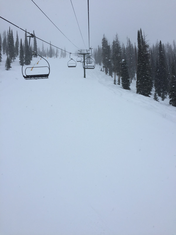
5 inches of snow on the Bachelor snow stake. And snowing. Will snow all day, and should see another 5"-6" during lift ops. Then another 6 "or so over night. Crystal Mt. starting to see some snow as well. Whistler reporting just 5cm over night but it will also snow throughout the day with lowering snow levels down to base village this evening with about 20cm or so forecast to fall over the next 24 hours. Then storm number 2 arrives later Wed/Thursday for a basic repeat of today's storm with the caveat that the temps will warm up and the freezing level will rise.
|
|

|
|
|
|
Obviously A snowHead isn't a real person
Obviously A snowHead isn't a real person
|
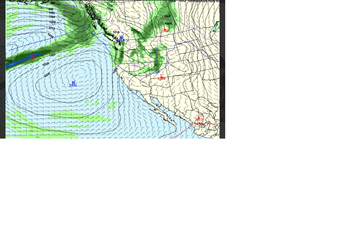
Storms coming in today and into Thursday are on the warm side for the PNW and BC Coast Range. Rising snow levels will be on order. This will reduce snow totals from earlier models. Snow levels look to rise above 1,800 meters in the Coast Range through the day today. Both the Euro and GFS are not agreeing on which way things look past the weekend. There's low pressure down South off the Calif. Central coast that is streaming up, and it's that energy that is bringing warm air into the PNW that will have an impact on rising snow levels to above 1,800 meters. There's a weak system off the Pacific near the Aleutian Islands with some colder air. That should arrive on Friday afternoon/night with lowering snow levels but not tons of energy.
A bit complicated for how things might play out past January 26th. But the jet stream looks to be favoring a bit of a Northerly track ATM, so that would tend to favor Canada and Northern Cascades, Idaho and Montana. The Canadian models seem to indicate that weak storms will pass through from January 26th-28th. But the Euro and GFS have a weak HP building that will split any low pressure systems. But both the GFS and Euro tend to have some agreement that around Jan. 28th there will be some weather pushing the HP Eastward and letting the storms come through. Have to wait a few more days to see how that all plays out.
One thing is for sure, January for British Columbia and the PNW has been very good. Tetons have had a remarkable run of snow fall.
|
|
|
|
|
|
Well, the person's real but it's just a made up name, see?
Well, the person's real but it's just a made up name, see?
|
| Toadman wrote: |
| Tetons have had a remarkable run of snow fall |

|
|
|
|
|
|
You need to Login to know who's really who.
You need to Login to know who's really who.
|
|
Snow Train continues for the PNW and Northern Rockies. 7 day forecast is looking somewhat promising, but don't want to jinx things either. But the Euro and GFS have been showing consistent low pressure activity coming in from the Gulf of Alaska with a NW flow. Current models have the storms tracking over Western BC and the Cascades and working across the Northern Parts of Idaho and into Montana. The models do show the storms tracking over the Tetons and into CO. Which means the Northern CO ski areas should see snow next week as well.
|
|
|
|
|
|
Anyway, snowHeads is much more fun if you do.
Anyway, snowHeads is much more fun if you do.
|
| hd wrote: |
| Toadman wrote: |
| Tetons have had a remarkable run of snow fall |
|
So far 22 days in January, and Jackson Hole has had 20 of those days with measurable snowfall. More on the way next week! Warm weather and rain up to at least 6,000 feet in the Coast Range and Cascades. Temps will remain on the warmer side through the weekend and start to drop.
Looking out past Feb. 1st, there are some interesting signs of more storminess for the PNW and Colorado Rockies.
Looks like Utah is in a "dirty ridge" situation, with a weak HP to the West of the Wasatch. Weak low pressure troughs coming off the Pacific are splitting to the North & South. Still providing a few inches of snow. But nothing to write home about. That patterns looks to continue for the next week or so.
|
|
|
|
|
|
You'll need to Register first of course.
You'll need to Register first of course.
|
| Quote: |
Looks like Utah is in a "dirty ridge" situation, with a weak HP to the West of the Wasatch. Weak low pressure troughs coming off the Pacific are splitting to the North & South. Still providing a few inches of snow. But nothing to write home about. That patterns looks to continue for the next week or so.
|
I know so annoying. Still got a few good lines Brighton and Solitude last two days. Some pockets deeper. Next week Jackson Hole. Driving from SLC will be ok?
|
|
|
|
|
|
|
|
|
Jackson Hole will be good next week. Drive up shouldn't be an issue. Looks like Monday is the better day to make the trip. Forecast calling for storminess in the Tetons from Tuesday into Thursday. Forecast calling for colder air to filter in with the jet stream forecast to start sagging South toward January 31stish or so. Could see a brief high pressure build up the very start of February, then Feb. 3/4th a return to storminess. Still too far out to know for sure. But next week looks like a decent but not great chance for modest snow for the Colorado Rockies and also for the PNW and British Columbia.
|
|
|
|
|
|
|
|
| Toadman wrote: |
| Jackson Hole will be good next week |
|
|
|
|
|
|
You'll get to see more forums and be part of the best ski club on the net.
You'll get to see more forums and be part of the best ski club on the net.
|
|
|
|
|
|
An interesting potential scenario developing for 7 days out. After a mild weekend GFS and ECMWF go full reverse ferret to a N'ly flow and deep cold. Could be T-shirt and shades on Sunday, face mask and thermals on Monday. Huge disparity though between the ensembles with several keeping it worryingly warm 
|
|
|
|
|
|
snowHeads are a friendly bunch.
snowHeads are a friendly bunch.
|
| hd wrote: |
| An interesting potential scenario developing for 7 days out. After a mild weekend GFS and ECMWF go full reverse ferret to a N'ly flow and deep cold. Could be T-shirt and shades on Sunday, face mask and thermals on Monday. Huge disparity though between the ensembles with several keeping it worryingly warm |
There's definitely some very cold Arctic air funneling down from Alaska/Northern Canada. How far it flows South is still a bit of a mystery. The Jet stream will help make that decision, along with how much oomph the cold pressure has too.
For those in the PNW - Including Whistler, they should see slightly lowering freezing levels today with some heavy wet snow Monday night. Cascade concrete!
Farther West in the Wasatch and CO Rockies will see about 6"-8" of snow for the Cottonwoods (Alta/Snowbird/Brighton/Solitude), and similar amounts for Steamboat and Aspen/Snowmass. Vail and Beaver Creek will get the left overs. Tetons are seeing snow Monday morning, and might eek out 6". Faster moving storm, with not a ton of energy.
2nd storm is right on the heels of the first, with similar snow totals forecast. Again, not a ton of energy, and the storms are moving at a pretty good clip. Tetons, Wasatch and CO Rockies should see another 6"-8" of snow.
For those over in Banff/Calgary and Eastern BC, (Panorama/Revelstoke) there's a storm on the Canadian/GFS/Euro models showing some good potential for January 31st/Feb. 1st time frame.
Model runs for Feb 1st and into the first week of February are indicating continued chances for storminess for the PNW/BC regions.
|
|
|
|
|
|
And love to help out and answer questions and of course, read each other's snow reports.
And love to help out and answer questions and of course, read each other's snow reports.
|
|
I was up at Squaw on Saturday - felt like a spring day, very very warm with the snow becoming very soft and sticky. It snowed on Saturday night/Sunday but looked marginal freezing level-wise and pretty wet and heavy. The week ahead looks super warm still, but yeah potentially a big change coming in a week. Fingers crossed... the south facing slopes will start to struggle at this rate.
|
|
|
|
|
|
|
|
|
Colder temperatures forecast to arrive around Sunday for the PNW and BC. Should see some snow for late Saturday/Sunday for Whistler and interior BC ski resorts. Should also see snow for Northern Idaho and Montana as well as the Tetons.
|
|
|
|
|
|
You know it makes sense.
|
I’m out in Sun Valley for a few days. Snowed just lightly the past few days adding up to 6” over a 48 period. Did a bit of ski touring this morning with nice weather and conditions.
 upload a picj upload a picj
|
|
|
|
|
|
Otherwise you'll just go on seeing the one name:
Otherwise you'll just go on seeing the one name:
|
Slopes have been empty. Especially with a bit of snow mid-week.
|
|
|
|
|
|
Poster: A snowHead
|
|
Forecast for the PNW and Colorado looking good for next week. Colder temps on the way with storm activity from Whistler down into Oregon from Saturday into Monday. Colorado and Wasatch of Northern Utah should see storm hitting on Monday night into Tuesday.
|
|
|
|
|
|
Obviously A snowHead isn't a real person
Obviously A snowHead isn't a real person
|
|
|
|
Well, the person's real but it's just a made up name, see?
Well, the person's real but it's just a made up name, see?
|
Warm up for the weekend in the West, and then things go colder for next week. Colorado Rockies and the Wasatch look to be on track for some decent accumulation from Monday/Tuesday.
Cold morning at 9F in the Sawtooths. Another nice tour and soft powder turns.
|
|
|
|
|
|
You need to Login to know who's really who.
You need to Login to know who's really who.
|
Looks like the Wasatch did okay last night with the Cottonwoods reporting between 17"-20" of snow. Colorado Summit County resorts didn't fare so well with about 5" falling overnight. More incoming for Wednesday though. Should see another foot for the Wasatch overnight.
PNW should see some interesting yo-yo effects with the snow levels. Freezing level forecast to go up as high as 6,500 feet before dropping below 4,000' by end of the week. Saturday could be a storm day skiing even.
|
|
|
|
|
|
Anyway, snowHeads is much more fun if you do.
Anyway, snowHeads is much more fun if you do.
|
I love Sun Valley. looks like you had a fine time.
We mostly skied Mission Ridge January. It's had 150% of usual January snow so it has been mostly very good. Quick report and some pics on blog - https://gortonator.blogspot.com/2020/02/winter-arrived-january-in-cascades.html - there were some fine powder days.
Snow level in jumping up again tonight and tmr in the Cascades but looks like Mission will be spared and could get some nice freshies Friday night, so guess where we are going. After that we're branching out for President's Weekend - heading far far north 
|
|
|
|
|
|
You'll need to Register first of course.
You'll need to Register first of course.
|
Big sky in Montana did alright last night. Looks good for the next few days. They say today was 3" up top and 2" at the bottom. On the north side of the mountain we found it deeper and/or with no crust below. At least it felt that way - fluffy and light. Pow on crust on South facing slopes and windblown in parts.
Snowing again tonight. Currently have around 1.5" of fresh snow in Big Sky Town centre already. I'm told 3-4 expected, have not verified this statement myself.
|
|
|
|
|
|
|
|
Atmospheric river has been hitting the Cascades. Whistler has had challenging conditions with high winds and upper mtn closures off and on the past week.
Big mud slide on Hwy 410 to Crystal Mtn this morning. Somewhere in the neighborhood of 5" of precip in the past 48 hrs. Looks to be cooling off Friday.
That AR will flow into Colorado Friday/Saturday with some cooler temps in place. Steamboat and Loveland and a few other ski areas in Summit County could see 2 feet of snow. (I had hoped to be in Vail this week, but work got in the way  ) In any event, there's plenty of snow to chase or play in this weekend just about where ever you decide to go. ) In any event, there's plenty of snow to chase or play in this weekend just about where ever you decide to go.
|
|
|
|
|
|
|
|
Ice storm in the Cascades. Lift closures and road closures due to mud slides. Maybe Saturday will be better. Although Crystal Mtn Washington is closed until Sunday.
I hear Breckenridge and Steamboat each received over 2 feet of snow. So, Colorado would be a very good place to be right about now.
|
|
|
|
|
|
You'll get to see more forums and be part of the best ski club on the net.
You'll get to see more forums and be part of the best ski club on the net.
|
|
A couple of feet in Little Cottonwood Canyon in the last 24 hours. They’re having a good year - even for them.
|
|
|
|
|
|
|
|
Big sky Dakota lift had up to 2ft. Knee to thigh deep depending on face. Hadn't opened the lift yesterday so last 48h of snow plus lots of windloading. Unreal. Again.
I hear Jackson got 18" and was best day of the season but Ikon crowds rushed into from across the US making lift queues extreme.
|
|
|
|
|
|
snowHeads are a friendly bunch.
snowHeads are a friendly bunch.
|
|
|
|
And love to help out and answer questions and of course, read each other's snow reports.
And love to help out and answer questions and of course, read each other's snow reports.
|
|
|
|
|
|
High pressure builds over the PNW for the next 3 days. Thursday a low pressure trough comes in off the North Pacific with cooler temps. Not much energy but should provide a refresh to the Coast Range and Cascades. Storm shows it working its way over to the Tetons and Colorado by Friday.
|
|
|
|
|
|
You know it makes sense.
|
Colorado did quite well with the last storm cycle. They had 4-5 days of recorded snow. Breck did very well with over 40" reported during the 5 days. Vail was right up there too. There's still some lingering clouds and orographic snow to be ahd, maybe 2"-6" for Monday. I saw some crazy pics of 30 plus minute lift lines for Vail back bowls.
https://theknow.denverpost.com/2020/02/07/vail-long-lift-lines-storm/233181/
Similar situation at Jackson Hole from the deep storm totals that they were getting this past week as well. Back country was at a level 4-5, so not the best place to try and get away from it all.
Current model runs for Euro and GFS indicate a cold pattern arriving around Thursday/Friday. There should be some low pressure activity for the weekend, but need to keep an eye on the storm track.
President's Day weekend could be a powder weekend. But one thing I know for sure...it will be crowded with families partaking in the winter wonderland of skiing out West!
|
|
|
|
|
|
Otherwise you'll just go on seeing the one name:
Otherwise you'll just go on seeing the one name:
|
Storm for Thursday/Friday is still on track, coming out of Gulf of Alaska. Not a big low pressure, but it will freshen up the slopes at Whistler, Mt Baker, and down toward Crystal Mtn. Friday could be a decent day to call in sick...That storm will move over to Idaho Panhandle. Currently doesn't look to drop further South though. There's another storm that comes in right on the heels of the first storm. A bit bigger, with more moisture, and temps a bit warmer, but should still have low enough snow levels that the bases of the Coast Range and Cascade resorts get snow, but denser snow. It looks to be arriving late Friday, and should snow all day on Saturday. Could be over 12" from Whistler into the central Cascades. Maybe 6" or so for Mt. Hood ski areas, and a bit less in central Oregon. Storm is slow moving so the potential for more snow accumulation is possible. That storm is tracking to drop further South as it transits and moves East, and should give Colorado a good shot of snow from Steamboat into the Summit county resorts around Sunday/Monday.
It seems like Colorado has been in the storm cycle fairly consistently, along with the Tetons in Wyoming the past 6 weeks.
|
|
|
|
|
|
Poster: A snowHead
|
GFS looking steady for BC/PNW/Tetons/Northern Idaho/SW Montana/Northern Colorado
 pic host site pic host site
|
|
|
|
|
|
Obviously A snowHead isn't a real person
Obviously A snowHead isn't a real person
|
No real changes in the forecast models. Coast Range and Northern Cascades should start seeing some snow this afternoon. Temps will be cold. Good quality snow. Will be a bit of a warm up as the next storm approaches. The Friday storm is a bit further South with the main energy, which will favor White Pass and Crystal down into Mt. Hood, OR. Mt Bachelor could do well with some cold air in place late Saturday that may produce some heavy snow fall at times.
The storms will move East and give Northern Idaho and SW Montana some decent accumulations. Maybe 2 feet plus over a 48 hour period. This 2nd storm is still looking to drop over the Tetons and into Northern Colorado, so Steamboat will do well. Summit County resorts of Vail, Breck, Copper, Keystone, Abasin should see over a foot of snow from Sunday into Monday (President's Day) I expect it will be very crowded on the slopes.
The Wasatch will also see snow on Sunday/Monday. Estimates range from 12" - 20" over a 48 hour period.
In short, lots of choices for those who still are looking to pull the trigger last minute for the holiday weekend!
|
|
|
|
|
|
Well, the person's real but it's just a made up name, see?
Well, the person's real but it's just a made up name, see?
|
|
@Toadman, looking at Aspen this weekend, trying to avoid the crazy Vail region crowd. How much are you thinking could hit there?
|
|
|
|
|
|
You need to Login to know who's really who.
You need to Login to know who's really who.
|
|
@LittleBullet, Aspen is going to be on the fringes of the storm track. They might see 6"-9" of snow from Sunday into Monday. A lot will depend on the jet stream and if it wiggles a bit South or stays a bit farther North. Another option you might want to consider is Steamboat. They usually do well with these types of storms that come from the NW. They could easily get over a foot and then some. Also the timing on the storm might come in a bit later Sunday night into Monday but again that is dependent on the strength of the jet stream. Either way, if you are looking for less crowded, Snowmass would be a good choice. It will still be busy, but the crowds tend to disperse well at such a big resort.
|
|
|
|
|
|
Anyway, snowHeads is much more fun if you do.
Anyway, snowHeads is much more fun if you do.
|
Looks like the updated GFS is showing a bit of a wiggle in that jet stream for Colorado. Winds will becoming out of the West and SW. This should favor areas such as Crested Butte, Snowmass, Steamboat and Beaver Creek. Maybe Telluride gets into the picture a little bit too.
The storm will move through a bit slower than previously forecast, which will also be a positive. As it moves through the Rockies, there will be a cool down in temps. So right side up pow. A bit heavier on the base and then lighter on top. So it should be snowing on Sunday with mostly dry on Saturday. Monday looks to be a prime powder day for most resorts in Colorado. Again depending on how slow the storm moves through and temps, there could be 12"+ or so for Steamboat and between 6"-12" for Crested Butte, Aspen/Snowmass and maybe Beaver Creek.
The Tetons should also do well with this storm from Saturday/Sunday with potential for 20"+ over a 48 time frame.
PNW has seen 9" fall overnight at Crystal Mtn., with Stevens Pass receiving 10". Mt Baker reported 3" overnight and Whistler received about 3" of fresh overnight as well. More is on the way for the Northern Cascades and Saturday night is still looking good for potential of a foot or more through Sunday.
Utah and the Wasatch appears to be on target for a foot plus from Saturday/Sunday as well with the Cottonwoods usually able to eek out a few more inches at the upper elevations.
|
|
|
|
|
|
You'll need to Register first of course.
You'll need to Register first of course.
|
Hey Mr Toadman. We’re jetting into SLC from Oz on Tuesday and plan to ski Alta and Snowbird on the Wednesday and Thursday before moving north road trip style to Jackson and Big Sky. We’ll have some beginners with us that have never seen snow.
It looks to me that it will be pretty dry for an extended period after this Sunday/Monday? The beginners will be with us until the 29th. Much chance of them getting snowed on do you reckon? Or will high pressure ruin the party?
|
|
|
|
|
|
|
|
| sbooker wrote: |
Hey Mr Toadman. We’re jetting into SLC from Oz on Tuesday and plan to ski Alta and Snowbird on the Wednesday and Thursday before moving north road trip style to Jackson and Big Sky. We’ll have some beginners with us that have never seen snow.
It looks to me that it will be pretty dry for an extended period after this Sunday/Monday? The beginners will be with us until the 29th. Much chance of them getting snowed on do you reckon? Or will high pressure ruin the party? |
Forecast models do show things going sunny as a high pressure builds up after Tuesday. Going out past the 7 day time frame, the long range models hint at possibly some activity out in the Feb. 24-25th time frame. But that's not reliable at all. So, yes, there's a chance that there could be snow in that time frame.
|
|
|
|
|
|
|
|
| Toadman wrote: |
| sbooker wrote: |
Hey Mr Toadman. We’re jetting into SLC from Oz on Tuesday and plan to ski Alta and Snowbird on the Wednesday and Thursday before moving north road trip style to Jackson and Big Sky. We’ll have some beginners with us that have never seen snow.
It looks to me that it will be pretty dry for an extended period after this Sunday/Monday? The beginners will be with us until the 29th. Much chance of them getting snowed on do you reckon? Or will high pressure ruin the party? |
Forecast models do show things going sunny as a high pressure builds up after Tuesday. Going out past the 7 day time frame, the long range models hint at possibly some activity out in the Feb. 24-25th time frame. But that's not reliable at all. So, yes, there's a chance that there could be snow in that time frame. |
Thanks
|
|
|
|
|
|
You'll get to see more forums and be part of the best ski club on the net.
You'll get to see more forums and be part of the best ski club on the net.
|
5 day snow precip still looks on track for the Coast Range, Cascades, Northern Idaho and the Tetons to get upwards of 20" of snow through Monday. Colorado Northern ski areas still look to receive around a foot of snow.

|
|
|
|
|
|
|
|
|
@Toadman, thanks for this. Really appreciated. Helped us a lot with planning. We're going to stick to the plan and head to Aspen-Snowmass Saturday evening for Sunday through to Tuesday riding. Keep these storms coming!
|
|
|
|
|
|
|
|