Poster: A snowHead
|
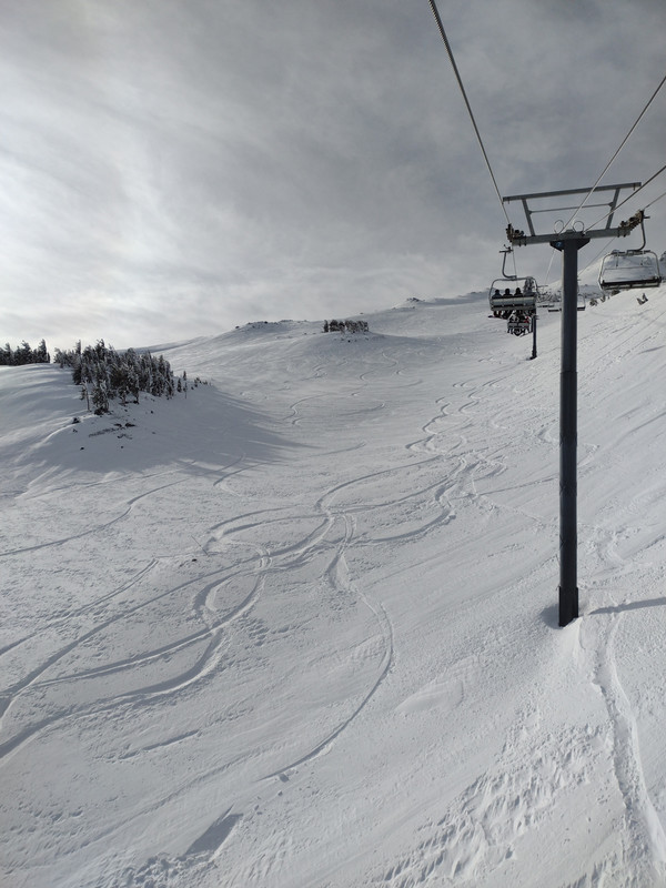
Soft wind buff on the hill this morning.

|
|

|
|
|
|
Obviously A snowHead isn't a real person
Obviously A snowHead isn't a real person
|
|
A nice 5" of dry and light powder for Sunday at the home hill. Low crowds for the morning meant lapping up the fun. Very solid early season start for the Western North America resorts. Another storm spinning out of the Gulf of AK means temperatures remain cold, and will meet up with some moist air coming up from the Pacific around Wednesday. Should converge a bit farther to the South around the Tahoe region. Could be some decent accumulation of 2 feet plus. The storm will work its way inland and currently tracking toward Northern Utah and Northern Colorado. Seems like the triple Nina magic is in full swing.
|
|
|
|
|
|
Well, the person's real but it's just a made up name, see?
Well, the person's real but it's just a made up name, see?
|
|
|
|
You need to Login to know who's really who.
You need to Login to know who's really who.
|
|
Tahoe resorts reporting up to a foot of new past 24 hours. That storm moved over to the Tetons and dropped 10" overnight. Snowmass received 7" and it's still snowing there. Vail received 6" overnight and lightly snowing this morning. Next storm is still on schedule for Thursday, so coming in a bit later than initially mentioned. Will be plenty of options for those who like to chase storms. PNW should see snow Thursday late morning into Thursday night.
|
|
|
|
|
|
Anyway, snowHeads is much more fun if you do.
Anyway, snowHeads is much more fun if you do.
|
I think mother nature is trying to repay me for the kidney I was forced to sell to pay for vehicle hire and lift tickets in Utah.
It's storm after storm so far!
|
|
|
|
|
|
You'll need to Register first of course.
You'll need to Register first of course.
|
It's a traffic jam of storms for BC, PNW, and Cali right now. First one came through on Thursday. I got home after a dinner with a supplier and had to break out the snow blower to remove 4" of dry and light powder off the driveway. Ski areas from BC down to the Tahoe resorts are reporting 4" -13" of snow. The next one is here and it's snowing. Or, the traffic is jammed up and moving slow, which is a very good thing and that first storm is just now leaving a bit late.
The 2nd storm is coming later this afternoon, and has some cold snow in tow. It's collected a decent amount of moisture as it comes in from the Pacific ocean. With it will come some stronger winds, so will likely be some upper mtn lift closures or delayed openings. Thank your local ski patrol as they will be busy. The 2nd storm is coming in a bit farther to the South of the first storm, so Oregon Cascades are looking at a foot plus from Friday night into Saturday morning. The storm will continue to move South from Oregon into NorCal and dump a significant amount of precip. in the 2 foot range at the higher elevations. Kirkwood, Sugar Bowl and that ski area formerly known as Squaw Valley could see over 3' of snow by Sunday morning. Even Mammoth is in the picture and could also see up to 2+ feet of snow by Sunday. The wildcard will be Sun Valley as the winds could push snow into that region late Saturday night or early Sunday morning. Tetons might get a glancing blow. Northern Utah might see some shrapnel from the 2nd storm on Sunday.
Way out in FI territory is a trough developing in the deep Eastern regions of the Aleutian Islands. If that one gets its act together we could see another round coming into focus toward the middle of next week. Will for now just keep an eye on things after getting a powder leg workout this weekend! 
Enjoy the powder you powder hounds!
|
|
|
|
|
|
|
|
|
|
|
|
|
|
Started snowing about 6am this morning in Central Oregon and hasn't stopped since. Just saw two XC skiers go by the house down the middle of the street. Plenty of snow to play with. Snow is on its way East to bless Colorado, Idaho, Wyoming and Utah.
|
|
|
|
|
|
You'll get to see more forums and be part of the best ski club on the net.
You'll get to see more forums and be part of the best ski club on the net.
|
|
Snow finally stopped about 9pm. Very odd storm that was a bit East and North of the Cascades of Central Oregon. Dropped more snow NE of Bachelor, which isn't necessarily a bad thing. Sierras and the Tahoe resorts got more than they could handle. About 3 feet of snow came down in a 24 hour period. Mammoth reported 20" in 24 hours. Sun Valley also have a foot of snow. It's currently snowing in Utah, Tetons and Northern Colorado. Will go cold and clear in the West for the next few days.
|
|
|
|
|
|
|
|
|
|
|
snowHeads are a friendly bunch.
snowHeads are a friendly bunch.
|
|
The storm that slammed into the West Coast on Saturday and then marched over Idaho/Wyoming/Colorado and Utah on Monday/Tuesday, is now slowly approaching the NE where it will dump a foot or so of snow in the New England states late Friday and into Saturday before unceramoniously marching on into the Atlantic. Who knows, maybe it finds its way to the European mountains before Christmas.
|
|
|
|
|
|
And love to help out and answer questions and of course, read each other's snow reports.
And love to help out and answer questions and of course, read each other's snow reports.
|
|
|
|
|
|
Jackson hole bumping up against 5 meters of snowfall before Christmas. Some indecisive weather inbound to the West/PNW later this week. Going very cold on Wednesday night Thursday. Some areas will be below 0F. A bit of weather will come into BC and Northern Washington, and scrape down into Northern Idaho and Montana. Seems like Tetons will get a glancing blow to bump that total snowfall up a few more inches before the New Year.
Then the weather will suddenly change its mind and bring a warm trough of air up from the South Pacific and we will go from 0F to low to mid 40's F for Christmas Eve and Christmas day. So, a bit of snow inbound on Friday for the PNW and the Sierras will transition to a wintery mix - aka "snain". The Rockies should stay a bit colder along with the Wasatch in Utah, so they could see some really high quality pow, aka cold smoke powder.
|
|
|
|
|
|
You know it makes sense.
|
Extremely cold temps on parts of the PNW and Mid-west. Montana ski areas -25F  That's before throwing the wind chill at -45F. Some of the Washington ski areas reporting 15+ inches in 24 hours. Unfortunately the warm trough of air coming out of the South Pacific is not too far behind the current cold front passing through currently. Will see rain at elevations up to 7,500 feet briefly on Friday late morning before a slight cool down, and then Christmas day looks to be warm above freezing before a possible 3rd trough of cooler air starts to push in from the North Pacific around Tuesday/Wednesday time frame. This one still looks tricky and depending on the jet stream could be a bit farther North of the 45th parallel are maybe smack dab in the middle as it comes ashore. That's before throwing the wind chill at -45F. Some of the Washington ski areas reporting 15+ inches in 24 hours. Unfortunately the warm trough of air coming out of the South Pacific is not too far behind the current cold front passing through currently. Will see rain at elevations up to 7,500 feet briefly on Friday late morning before a slight cool down, and then Christmas day looks to be warm above freezing before a possible 3rd trough of cooler air starts to push in from the North Pacific around Tuesday/Wednesday time frame. This one still looks tricky and depending on the jet stream could be a bit farther North of the 45th parallel are maybe smack dab in the middle as it comes ashore.
|
|
|
|
|
|
Otherwise you'll just go on seeing the one name:
Otherwise you'll just go on seeing the one name:
|
|
Lots of warm air pushing through the West Coast yesterday and for Christmas day. One of the few decent places is Jackson Hole with temps in the 20's and a few inches of fresh. Whistler received about 5" of heavy, wet snow and temps are right around the freezing mark. Forecast calls for temps to cool off around mid-week with potential for fresh round of snow Wednesday.
|
|
|
|
|
|
Poster: A snowHead
|
Atmospheric River (AR) is on its way for the PNW. The jet stream decided to visit Canada for a few days, and is set to slowly descend South over the next few days as a train of moisture makes its way to the West Coast. As the first wave comes in, temps will be on the warmer side, with high snow levels for Tuesday and start to cool into Wednesday. Because of the warmer temps, the snow will be wet and heavy, but will help to rebuild the base from the recent Christmas day rain. The winds might be an issue to start with and upper mtn. lifts most likely will be delayed in opening on Wednesday.
The next wave of energy will arrive sometime on Thursday with initially a bit higher elevation snow levels but decreasing as the storm moves through and the temps begin to drop.
7 day totals from the AR look to be pretty impressive for the Sierras, Northern/Central Idaho and Wasatch range in Utah. The Tetons could also fair quite well too. As will the Central and SW CO (Telluride).

Farther out toward New Year's Day, looks to have a 3rd wave of low pressure coming on shore. But need to wait and watch the models to see if this storm will trend more into California or possibly a bit further North into Oregon.
|
|
|
|
|
|
Obviously A snowHead isn't a real person
Obviously A snowHead isn't a real person
|
|
Heavy snow and strong winds (70+mph) have shut down all the high alpine lifts in the PNW today. The storm will continue throughout the evening, and forecast calling for slightly colder temps as the storm passes. The 2nd storm will be directly on the heals of this current storm. Continued cold temps and potential for a foot of snow over a 24 hour period for the central Cascade mountains. Utah will also benefit and possibly see 2 feet over the next 48 hours. Cold temps equals that "best snow on Earth" label for the Cottonwoods. That 2nd storm arriving into Utah on Friday and into Saturday could see another 2 feet of snow delivered. Anyone looking to chase powder would be wise to get after it. Of course with all that new copious amounts of fresh snow also means high avy danger. So, ski patrol will be very busy in a lot of ski resorts from the PNW/Tetons/Colorado resorts.
|
|
|
|
|
|
Well, the person's real but it's just a made up name, see?
Well, the person's real but it's just a made up name, see?
|
They certainly called that correctly!
|
|
|
|
|
|
You need to Login to know who's really who.
You need to Login to know who's really who.
|
The Pow Train stopped off in the PNW and the Sierra's last night and delivered 15+ inches of wind affected snow on N-NW facing slopes. Whistler received a glancing blow with a top up of about 4". The train moved on to the East and delivered 6" to Sun Valley, then to JHMR where it deposited 10", Alta/Snowbird recorded 17" and 18" respectively. Steamboat just missed the foot mark with 11" of fresh champagne powder. Aspen/Snowmass with 6" of snow. Even Snowbowl in Northern AZ scored 13" of snow!
The next train is arriving Thursday evening in the PNW and Northern Calif. Temps will be a bit cooler than the Wednesday train. The Thursday night pow train will work it's way East and make stops in Northern Utah, Western Wyoming and Southern Colorado region, plus bonus stops in New Mexico (Taos) and again in Northern Arizona. Similar snow accumulation to the Wednesday pow train should be deposited by the Thursday night pow train. Looks like the end of the 2022 winter season is going out with a bang in North America!
Out a bit farther down the snow tunnel, appears to be the light of another pow train arriving perhaps the start of the New Year. Will keep an eye on the pow train schedule to see if there are any delays or track switches. In the meantime, for all those lucky enough to be in the pow train express, enjoy the ride! 
|
|
|
|
|
|
Anyway, snowHeads is much more fun if you do.
Anyway, snowHeads is much more fun if you do.
|
|
|
|
You'll need to Register first of course.
You'll need to Register first of course.
|
The Pow Train Express came in a bit early as I woke to an inch of snow in my driveway this morning. It's currently snowing big, soft flakes in the Cascades this morning and will continue through out the day. Ramping up later this evening.
Here's a short video of some avy control work yesterday on Whistler;
https://www.youtube.com/shorts/12YOQk8mSQY
|
|
|
|
|
|
|
|
Looks can be deceiving. A wee bit of a oh so very light subtle rain crust layer in there in the middle. However, it's currently getting buried by the snow that's been falling all day.

|
|
|
|
|
|
|
|
|
|
|
You'll get to see more forums and be part of the best ski club on the net.
You'll get to see more forums and be part of the best ski club on the net.
|
Snow Express Train number 3 is currently dumping 3 feet of snow in the Sierra's. It's another AR, so, it's on the warmish side, with high snow levels to around 7,000'.
Utah ski areas reporting around 9"-12". They should see similar numbers again Sunday. Colorado ski resorts will get the leftovers on Sunday with a few inches.
The next round of precip hits the Sierras on Monday. Not as much moisture as the current storm. It will leave a few crumbs for Utah and Colorado.
The jet stream is currently visiting Northern California for a few days, so most storm energy is headed to the Tahoe ski areas.
|
|
|
|
|
|
|
|
|
|
|
snowHeads are a friendly bunch.
snowHeads are a friendly bunch.
|
|
|
|
And love to help out and answer questions and of course, read each other's snow reports.
And love to help out and answer questions and of course, read each other's snow reports.
|
| Toadman wrote: |
| First day of the new year for me. Mt. Bachelor patrol and lift ops got the Summit chair spinning for the first time this season. It was well worth the wait to experience some fresh turns. |
Just wanted to say thank you for all the updates in this thread. Have a CO trip planned for late Jan/early Feb and it's great to see conditions are building up like this!
|
|
|
|
|
|
|
|
|
|
|
You know it makes sense.
|
Bomb cyclone meets Atmospheric River. News at 9, 10 AND 11!!!
Yet another in a long line of AR's is coming off the Pacific on Wednesday. These are very long bands of moisture laden low pressure troughs that originate around the Hawaiian islands. Current models show this storm headed toward Northern California and the Sierra's. NorCal and Central California have been hit with a large amount of moisture the past week resulting in wide spread flooding and mudslides.
The models indicate some cold air circulating and trickling down from the Gulf of AK, which could provide a some activity for the Cascades in Oregon. As is normal for these AR's, they come in warm and as air is drawn in from the North, they cool as they move East resulting in lowering snow levels.
This storm is not as strong as the previous one and is looking to fizzle out a bit as it moves East over Utah, Wyoming and Colorado.
Farther out toward the weekend models indicate yet another storm coming on shore more Northerly for Washington and Oregon. Currently looking like Wyoming, Northern Utah and Colorado will see snow from this event around Sunday.
|
|
|
|
|
|
Otherwise you'll just go on seeing the one name:
Otherwise you'll just go on seeing the one name:
|
|
|
|
Poster: A snowHead
|
Hi, we'll be skiing mostly in Aspen with a stop off at A-Basin on the way back to Denver. I've been in Chamonix for the last few weeks and while that's been great, the snowpack doesn't really compare this year!
|
|
|
|
|
|
Obviously A snowHead isn't a real person
Obviously A snowHead isn't a real person
|
| schauspiele wrote: |
Hi, we'll be skiing mostly in Aspen with a stop off at A-Basin on the way back to Denver. I've been in Chamonix for the last few weeks and while that's been great, the snowpack doesn't really compare this year! |
Weather trends continue to look promising at least for the next 10 days. Obviously late January is way off, but conditions are excellent all over Colorado right now. The Aspen/Snowmass area should see some more snow later into the weekend.
|
|
|
|
|
|
Well, the person's real but it's just a made up name, see?
Well, the person's real but it's just a made up name, see?
|
| Toadman wrote: |
| schauspiele wrote: |
Hi, we'll be skiing mostly in Aspen with a stop off at A-Basin on the way back to Denver. I've been in Chamonix for the last few weeks and while that's been great, the snowpack doesn't really compare this year! |
Weather trends continue to look promising at least for the next 10 days. Obviously late January is way off, but conditions are excellent all over Colorado right now. The Aspen/Snowmass area should see some more snow later into the weekend. |
Good to hear! The snow update emails the resort are sending out are very heartening but it's good to cross-reference them with an objective source!
|
|
|
|
|
|
You need to Login to know who's really who.
You need to Login to know who's really who.
|
The Bay Area in California is getting absolutely hammered by high winds and up to 10" of rain in some areas of Central California. Mudslides are prevalent. Heavy flooding and rivers are overflowing. Coastal areas are taking a major beating. Unfortunately for California there is no immediate relief in sight as another AR is coming into the same general area. Models do show it currently a bit farther to the North this time around, and not quite as strong or as large. Both GFS and the Euro models showing it splitting and fragmenting as it comes inland. Some of that energy will dissipate over Oregon and into Central and Eastern Washington and Northern Idaho. While the Southerly split will flow toward Southern Utah and into Colorado on Sunday/Monday time frame. Not a ton of energy or moisture when it arrives but should provide a small dust up and refresh of the slopes in Northern and Central Colorado. The Summit County ski resorts won't see much from this storm.
There's one more AR that is showing way out in the Pacific that is forming out past and to the South of the Aleutian island chain. This one is too far out to accurately tell where it will come ashore. Time frame is toward the latter part of next week (Jan. 13-15th). Will just keep an eye on things and watch it develop. There will be a slight warming trend toward Jan. 8th time frame for a few days, as the AR that comes through over the weekend leaves a bit of warmer air trailing behind it. Most likely the Tahoe ski resorts will get a bit of rain at high elevations on Monday from what's left over, so this weekend would be the time to go hit the slopes in California.
|
|
|
|
|
|
Anyway, snowHeads is much more fun if you do.
Anyway, snowHeads is much more fun if you do.
|
|
North America is crushing Europe this year for snow
|
|
|
|
|
|
You'll need to Register first of course.
You'll need to Register first of course.
|
|
|
|
|
|
| skithesteelstealtheski wrote: |
| North America is crushing Europe this year for snow |
Yes, the North America Western Mountains are having an excellent season to date. New England had a good holiday period, but it's been warm there recently. But they too will see some cold air coming there way later this week, but sadly it looks to be short lived with some warmer air coming next week.
Some ski areas have over 250" of snowfall for the season. Quite remarkable with ~3 months more of snowfall to come. Hopefully the triple Nina winter continues to deliver.
|
|
|
|
|
|
|
|
|
|
|
You'll get to see more forums and be part of the best ski club on the net.
You'll get to see more forums and be part of the best ski club on the net.
|
Low pressure troughs continue to stack up off the North Pacific and march to the West Coast. It appears that California has a sign out that says, "Open for business." As the storms continue to move that direction.
The current AR that is hammering Central California and the Sierra's will make its way to Southern Utah Monday/Tuesday and on into Colorado as well.

You can see from the satellite image that yet another monster storm is building out in the Aleutian Islands, and will make its way toward the Western US sometime around Wednesday/Thursday. There will be a bit of a warming spell between storms for the PNW and NorCal early next week before the next storm moves on shore.
Still watching where the main thrust of energy will make landfall.
|
|
|
|
|
|
|
|
Not a lot of it has reached Kicking Horse unfortunately 
But pretty happy California is getting some this year as drought there has significant impact on things far more important than skiing.
|
|
|
|
|
|
|
|