Poster: A snowHead
|
| MoodyFFS wrote: |
| If there is precipitation falling as rain at 1,800m it’s likely to be snow further up right? |
Worth checking the freezing level (recorded in some snow/weather forecasts), but the usual assumption is it gets colder the higher you get so simply, rain should be snow where the air temps are at or around freezing (yes, lots of factors can affect this and higher altitude doesn't always mean colder...). Judging by general temps around at the moment it's likely to be snow at 1800m and a fair bit below too. I use the rule of thumb that 1mm of rain equals 10mm of snow.
|
|

|
|
|
|
Obviously A snowHead isn't a real person
Obviously A snowHead isn't a real person
|
|
Another general rule of thumb is the temperature decreases by 0.6 to 1 degree C for every 100m you go up, depending on wind chill. So, if it's raining at 4 degrees C in a resort at 1000m, at 1800m it'll be below 0 and probably snowing.
|
|
|
|
|
|
Well, the person's real but it's just a made up name, see?
Well, the person's real but it's just a made up name, see?
|
| MajorQ wrote: |
| Another general rule of thumb is the temperature decreases by 0.6 to 1 degree C for every 100m you go up, depending on wind chill. So, if it's raining at 4 degrees C in a resort at 1000m, at 1800m it'll be below 0 and probably snowing. |
Thanks, that was the one I was fumbling to find - couldn't remember off the top of my head 
|
|
|
|
|
|
You need to Login to know who's really who.
You need to Login to know who's really who.
|
|
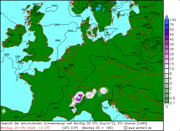
@MoodyFFS, maybe, depends on the temps, but that chart is 850mb which roughly corresponds to an altitude between 1400-1600m for the alps most of the time.
|
|
|
|
|
|
Anyway, snowHeads is much more fun if you do.
Anyway, snowHeads is much more fun if you do.
|
|
@denfinella,it was a joke responding to @Rob Mackley’s comment which is why I mentioned his name in the post.
|
|
|
|
|
|
You'll need to Register first of course.
You'll need to Register first of course.
|
|
@Randyp909, following up @MajorQ, my even more broad brush interpretation is you lose 2C for every 300m. So if it’s 10C at sea level it’ll be roughly 0C at 1500m. But given that snow level is likely to be lower than freezing level you might expect the snow line to begin around 1300m. That is however very rough!
|
|
|
|
|
|
|
|
|
|
|
|
|
@kitenski,
Which resorts didn't try to open for Xmas, and when?
|
|
|
|
|
|
You'll get to see more forums and be part of the best ski club on the net.
You'll get to see more forums and be part of the best ski club on the net.
|
|
Just to add to the lapse rate (variation of temperature with altitude) rules of thumb. The rate of change is higher (up to 1C per 100m) when the air is dry, and low (more like 0.5C per 100m) when the air is moist. So, if you're thinking about this when it's snowing, the latter rate is probably more accurate
|
|
|
|
|
|
|
|
|
@viv, It's this difference between the dry adiabatic lapse rate (DALR) and saturated adiabatic lapse rate (SALR) that explains the Foehn effect. But I would guess you knew that already.
|
|
|
|
|
|
snowHeads are a friendly bunch.
snowHeads are a friendly bunch.
|
| Quote: |
| Looks like a proper fall presently in the French Alps , I know it’s looking at webcams but... |
Tap, tap, BOOM!  Arrived in Tignes winter wonderland late pm today after a very snowy drive up from Bourg St Maurice. Heavy snow falling from Ste Foye - the road was very snow covered all the way to Tignes after that. Arrived in Tignes winter wonderland late pm today after a very snowy drive up from Bourg St Maurice. Heavy snow falling from Ste Foye - the road was very snow covered all the way to Tignes after that.
|
|
|
|
|
|
And love to help out and answer questions and of course, read each other's snow reports.
And love to help out and answer questions and of course, read each other's snow reports.
|
| mountainaddict wrote: |
| Quote: |
| Looks like a proper fall presently in the French Alps , I know it’s looking at webcams but... |
Tap, tap, BOOM! Arrived in Tignes winter wonderland late pm today after a very snowy drive up from Bourg St Maurice. Heavy snow falling from Ste Foye - the road was very snow covered all the way to Tignes after that.
|
@admin like button on this forum urgently required
|
|
|
|
|
|
|
|
looks like they had quite a bit more than was forecast........looking good
roll on the 18th Dec
|
|
|
|
|
|
You know it makes sense.
|
|
And fell on frozen ground too
|
|
|
|
|
|
Otherwise you'll just go on seeing the one name:
Otherwise you'll just go on seeing the one name:
|
| mountainaddict wrote: |
| Quote: |
| Looks like a proper fall presently in the French Alps , I know it’s looking at webcams but... |
Tap, tap, BOOM! Arrived in Tignes winter wonderland late pm today after a very snowy drive up from Bourg St Maurice. Heavy snow falling from Ste Foye - the road was very snow covered all the way to Tignes after that.
|
Splendid!!!
|
|
|
|
|
|
Poster: A snowHead
|
|
|
|
Obviously A snowHead isn't a real person
Obviously A snowHead isn't a real person
|
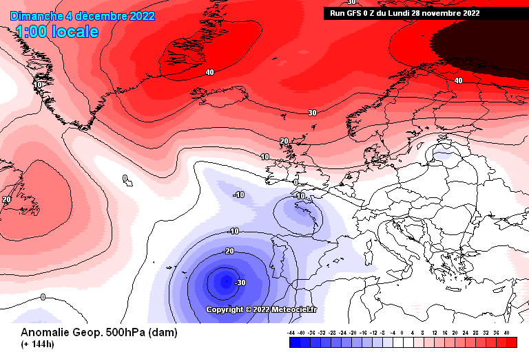
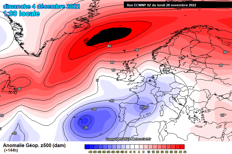
Far end of GFS (so do not take seriously), but throwing out suggestions of the sort of blocking @polo has been talking about.
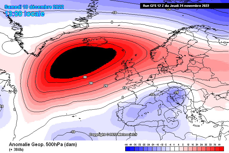
Were something like this to happen the jet would be forced South allowing cold air to flow down from the North. In likelihood this would tend to mean snowfall would favour the southern side of the Alps, but a lot of ifs and buts in there.
|
|
|
|
|
|
Well, the person's real but it's just a made up name, see?
Well, the person's real but it's just a made up name, see?
|
Yes can't stress enough how unusual these charts are for early Dec. It looks like a minimum 2 weeks of HLB (high lattitude blocking). Blocking for those that are unsure is just a large area of high pressure that diverts the usual west to east vortex wind flow that travels around the north pole. Like dropping a large stone in a stream, the jet has to buckle around the blockage, becoming more south to north (meridonal) than west to east (zonal), pulling down cold air that is normally bottled up over the arctic.
Short term snowfall for the next week or so from the NW but ending up over the med.....numbers will shift, this is just the GFS 00z Op

Can see temps are mostly below average for alps with a deep cold pool building to the NE as cold air comes around the back of the block

And just for fun, here's one of the many options cropping up....GFS Para (about to become the Op model this week), shows the potential for a very cold and snowy undercut travelling east to west into central europe.

It looks like quite a slow moving pattern overall. The danger is high pressure doesn't stay far enough north and instead sinks into europe, cutting off flow from both the east and the west. Also it's quite possible that the euro-scandi high never gets fully into greenland, leaving us in a dry no mans land. But as things currently stand, it looks promising, 80% chance of long cold spell and some useful top ups via southerly jet and outside chance of northerly blasts further into Dec.
|
|
|
|
|
|
You need to Login to know who's really who.
You need to Login to know who's really who.
|
| MajorQ wrote: |
| Another general rule of thumb is the temperature decreases by 0.6 to 1 degree C for every 100m you go up, depending on wind chill. So, if it's raining at 4 degrees C in a resort at 1000m, at 1800m it'll be below 0 and probably snowing. |
or glorius sunshine and +10C
|
|
|
|
|
|
Anyway, snowHeads is much more fun if you do.
Anyway, snowHeads is much more fun if you do.
|
|
@davidof, that would be some unique weather inversion if it was raining low down and sunny higher up
|
|
|
|
|
|
You'll need to Register first of course.
You'll need to Register first of course.
|
|
The weather experts I follow on Twitter are getting very excited this morning !
|
|
|
|
|
|
|
|
New version of GFS is the pick of the overnight runs…..sadly way too far to be accurate, but you can see the potential for major disruption when a Greenland high puts a big stick in the vortex wheel

|
|
|
|
|
|
|
|
|
|
|
You'll get to see more forums and be part of the best ski club on the net.
You'll get to see more forums and be part of the best ski club on the net.
|
@BobinCH, frozen planet / snowmaggedon for UK and central europe.....the air source is coming directly from the arctic and bringing lots of snow via north sea. It is definitely looking dry early dec across all the models, but you can see the old GFS Op (green in your ensembles) also picks up on the northerly idea around the 10th....-5c at 1500m and precip spike. But of course it's just one of a hundred possibilities at that range. Btw the new version of GFS goes live on the 29th so all the old links will be updated to the new suite.
Tuesdays snowfall looks moderate but a welcome 5-10cm down to 1200m ish in the NW, before at least a week or so of cool and settled conditions. There are 3 options on the table beyond that in my view.....worst case europe remains under high pressure (dry and average temps), second best is the high stays north and cold continues to feed in from the east (great for piste prep), and best case the high shifts NW to greenland and we get a northerly (cold and lots of snow as above).
|
|
|
|
|
|
|
|
|
@polo, that would be a nice birthday present for 13th!
|
|
|
|
|
|
snowHeads are a friendly bunch.
snowHeads are a friendly bunch.
|
@BobinCH, repeats on the 06z but hasn't got support from the mean yet....and one more risk emerging is the low could end up too far west (west based -NAO).
Re. snow for your birthday, am sure we are all rooting for you. You can never have too much snow it seems.
|
|
|
|
|
|
And love to help out and answer questions and of course, read each other's snow reports.
And love to help out and answer questions and of course, read each other's snow reports.
|
@polo,
| Quote: |
You can never have too much snow it seems
|
Yes, yes, you can!!
|
|
|
|
|
|
|
|
| under a new name wrote: |
@polo,
| Quote: |
You can never have too much snow it seems
|
Yes, yes, you can!! |
No, no you really can’t! Even the dog agrees

|
|
|
|
|
|
You know it makes sense.
|
|
@BobinCH, no really, avvy level 5 and forbidden to walk in the streets is too much snow!
|
|
|
|
|
|
Otherwise you'll just go on seeing the one name:
Otherwise you'll just go on seeing the one name:
|
Zermatt Dec 10th,11th, showing a humongous snow spike 
|
|
|
|
|
|
Poster: A snowHead
|
|
|
|
Obviously A snowHead isn't a real person
Obviously A snowHead isn't a real person
|
|
@nozawaonsen, just as well it's +/- cold, eh?
|
|
|
|
|
|
Well, the person's real but it's just a made up name, see?
Well, the person's real but it's just a made up name, see?
|
| nozawaonsen wrote: |
....
Some potential out in FI, particularly for the southern Alps, but very much in FI. |
I see that WePowder is sticking its neck out for a substantial amount of snow this coming Saturday 3rd for Limone Piemonte with upwards of 68cm - it looks according to their weather-map, very very localised, and when it's such a small dynamic area then a lot can go awry in five days.

That said YR.no are predicting circa 35 on the Friday, and dear old Snow-forecast, nada....
|
|
|
|
|
|
You need to Login to know who's really who.
You need to Login to know who's really who.
|
|
|
|
Anyway, snowHeads is much more fun if you do.
Anyway, snowHeads is much more fun if you do.
|
|
I saw that and wondered were the wepowder computers broken or gone on auto pilot as he didn't refer to it in his narrative and could see literally nothing on bergfex
|
|
|
|
|
|
You'll need to Register first of course.
You'll need to Register first of course.
|
| 8611 wrote: |
| I saw that and wondered were the wepowder computers broken or gone on auto pilot as he didn't refer to it in his narrative |
https://wepowder.com/en/forum/topic/285843
| Quote: |
Latest update: 28 Nov 2022 - 12:20
Southern Alps some snow?
Small shifts could still have a big impact on the expected snowfall in the southern Alps. In recent days, for instance, we saw some maps come through with retour d'Est signals. It is indeed true that high pressure northeast of the Alps is favourable for a retour d'Est to develop, but that does not mean that everything is certain yet. |
|
|
|
|
|
|
|
|
Currently dumping along a wide swath of area in the PNW mountains. This will be a good storm for anyone located in the Mountain West of North America. It's a very chilly -17C at Whistler-Blackcomb this morning! Should start to see another round of snow inbound on the tails of the current storm. I woke up to an inch and snowing at my place in Central Oregon this morning. Most ski resorts are already operating from a few storms that came in at the beginning of November. This current storm will be a nice top up for the bases.
Bonus will be the next storm coming out of the Gulf of AK with colder air and some moisture to add to the fun later this week.
It's bee a very good start to the season here in North America.
And, yes, you can have too much snow sometimes!!!
|
|
|
|
|
|
|
|
|
Cold next week in the UK with the easterly but liking fairly dry. could be useful for Glenshee to get their snow slope established.
|
|
|
|
|
|
You'll get to see more forums and be part of the best ski club on the net.
You'll get to see more forums and be part of the best ski club on the net.
|
Well after weeks of intense weather model watching and hopes and prayers for a good early season, ultimately the favorable ENSO / expected block pattern fails entirely. Resulting in lengthy soul destroying dry conditions, especially the first 7-8 weeks.
There is no other way to say it, nothing can be done now to change the outcome. It’s over.
RIP autumn, let’s move on to the real deal.
|
|
|
|
|
|
|
|
@polo, looks dry across the alpes for the next week. At least its cold which should be good for snow making.
I've been watching intently as we travel to la plagne on 16th December.
All it ever takes though is one big dump and we are back in business. Anything could still happen
|
|
|
|
|
|
|
|